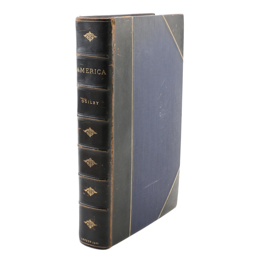


"America" Book with Illustrated Maps by John Ogilby, 1671
Item Details
An antiquarian first edition of America: Being the Latest, and Most Accurate Description of the New World featuring numerous authors and illustrations by John Ogilby. This book contains supplemental text and illustrations of maps and geographic routing. The volume is richly illustrated throughout and features full page portraits, illustrations and maps. For a detailed list, including those listed in the colophon but not included in this copy, please see below. An engraving of Carolina has been replaced with an altered copy originally presented within the second printing. The book was printed by the author, in London, during 1671.
2°: [ 1 ], A 4 [ 1 ] B 4 – K 4, L 6 – X 6, Y 4, Z 6 – OOO 6, PPP 4; pp. [ 6 ], 1 – [ 676 ] with extensive tipped in maps and illustrations, see details below.
Several page misprints are present, though all pages from the main text appear to be present:
K1 printed as K†
P.120 (leaf [ O6 ]) misprinted as 116
P, 137 (leaf Q3) misprinted as 317
P. 185 (leaf V3 recto) misprinted as 179, corrected in an unknown hand
P. 188 (leaf V4 verso) misprinted as 170, corrected in an unknown hand
P. 317 (leaf Hh5 recto) misprinted as 217
P. 437 (leaf Sſ5 recto) misprinted as 439
P. 637 misprinted as 640 (leaf MMM3 recto)
P. 640 misprinted as 636 (leaf [ Mmm4 ] verso)
The following illustrations and maps are tipped in throughout the text (specific locations detailed below):
- Frontispiece tipped in prior to the title page
- Fold-out map “Totius Americæ” tipped in between [ A4 ] and B1, creasing and small tears in creases
- Single-leaf portrait “Christofel Colonus” (Christopher Columbus) tipped in between G1 and G2 (p.42 and 43)
- Two-leaf illustrated map “Angro op Tercera” tipped in between H2 and [ H3 ] (p. 52 and 53)
- Single-leaf portrait “Americus Vesputius” (Amerigo Vespucci) tipped in between I2 and [ I3 ] (p. 60 and 61)
- Single-leaf portrait “Ferdinand Magellanus” (Ferdinand Magellan) tipped in between L3 and [ L4 ] (p. 78 and 79)
- Two-leaf illustrated map “Vetus Mexico” tipped in between M1 and M2 (p. 86 & 87)
MISSING: “Athabaliba” p. 97 (as listed in colophon listing ’Directions for placing the Whole-sheet Prints in this Volume of America)
- Two-leaf map “Novi Belgii” (Novum Belgium) tipped in between [ S6 ] and T1 (p. 168 and 169)
- Two-leaf map “Noua Terræ-Mariæ Tabula” (Mary-Land) tipped in between V1 and V2 (p. 182 and 183)
- Two-leaf map “Nova Virginiæ Tabula” tipped in between [ V6 ] and X1 (p. 192 and 193)
- Large fold-out map “A New Description of Carolina” tipped in between [ X6 ] and Y1 (p. 204 and 205; reinforced and repaired, small tear in lower quadrant near gutter, tear in center at crease; noted as a replacement from second edition.
MISSING: ’Virginiæ pars Australis & Florida” p. 213 (as per colophon)
- Two-leaf map “Pagus Hispanorum” tipped in between Z3 and [ Z4 ]
- Two-leaf map “Yucatan” and two-leaf illustration “St. Francisco de Campeche” tipped in between [ Z5 ] and [ Z6 ] (p. 222 and 223)
- Two-leaf illustration “Truxillo” tipped in between Aa3 and [ Aa4 ] (p. 230 and 231)
- Two-leaf map “Nova Hispania, Nova Galicia, Guatimala” tipped in between Bb1 and Bb2 (p. 238 and 239)
- Two-leaf, fold-out illustrated map “Nova Mexico” tipped in between Bb3 and [ Bb4 ] (p. 242 and 243)
MISSING: “Muteczuma” p.253 (as per colophon)
- Two-leaf illustration “Portus Acapulco” tipped in between [ Cc6 ] and Dd1 (p. 260 and 261)
MISSING: “Viztlipuztli” p. 297 (as per colophon)
MISSING: “Insulæ Amercanæ in Oceano Septentrionali” p. 304 (as per colophon)
- Two-leaf map “Mappa Æstivarum Insularum alias Barmudes” tipped in between Hh1 and Hh2 (p. 310 and 311)
- Two-leaf illustrated map “Urbs Domengo in Hispaniola” tipped in between [ Hh5 ] and [Hh6] (p. 318 and 319)
- Two-leaf illustration “Porto Rico” tipped in between Ii3 and [ Ii4 ] (p. 326 and 327)
- Two-leaf illustration “Havana” tipped in between [ Ii6 ] and Kk1 (p. 332 and 333)
- Fold-out map “Jamaicæ” (Jamaica) tipped in between Kk2 and Kk3 (p. 336 and 337)
- Two-leaf illustration “De Stadt St. Martin” (Urbs Martini) tipped in between [ Mm4 ] and [ Mm5 ] (p. 364 and 365)
- Two-leaf map “Barbados” Tipped in between [ Nn4 ] and [ Nn5 ] (p. 376 and 377) note: not listed in “Direction for placing the Whole-Sheet Prints in the Volume of America”
- Two-leaf illustration “Cartagena” tipped in between [ Pp4 ] and [ Pp5 ] (p. 400 and 401)
- Two-leaf map “Terra Firma et Novum Regnum Granatense et Popayan” tipped in between Qq2 and Qq3 (p. 408 and 409)
- Two-leaf map “Peru” tipped in between [ Qq4 ] and [ Qq5 ] (p. 412 and 413),
- Single-leaf portrait “Francisco Pisarro” tipped in between [ Rr6 ] and Sſ1
- Two-leaf illustration “Cusco” tipped in between Vv2 and Vv3 (p. 456 and 457)
- Two-leaf illustration “Potosi” tipped in between [ Vv5 ] and [ Vv6 ] (p. 462 and 463)
- Two-leaf illustration “Callao de Lima” tipped in between Xx1 and Xx2 (p. 466 and 467)
- Two-leaf map “Chili” tipped in between Xx3 and [ Xx4 ] (p. 370 and 371),
- Two-leaf map “Magellanica” tipped in between [ Xx4 ] and [ Xx5 ] (p. 472 and 473)
- Two-leaf map “Paraquaria vulgo Paragvay cum adjacentibus” tipped in between [ Xx5 ] and [ Xx6 ] (p. 474 and 475)
- Two-leaf map “Brasilia” tipped in between [ Xx6 ] and Yy1 (p. 476 and 477)
- Two-leaf illustration “Sinus Omnium Sanctorum” tipped in between Aaa1 and Aaa2 (p. 502 and 503)
- Two-leaf illustration “Olinda de Phernambuco” tipped in between Aaa2 and Aaa3 (p. 504 and 505)
- Two-leaf illustration “Ostium Flumines Paraybæ” Tipped in between [ Aaa4 ] and [ Aaa5] (p. 508 and 509)
- Two two-leaf illustrations “I. Tamaraca” and “Fluvius Grandis” tipped in between Bbb2 and Bbb3 (p. 516 and 517)
MISSING: “Siara” p. 517 (as per colophon)
- Two-leaf illustrated map “Urbs Salvador” tipped in between Bbb3 and [ Bbb4 ] (p. 518 and 519)
- Two-leaf illustration “Obsidio et Expugnatio Portus Calvi” tipped in between Eee3 and [ Eee4] (p. 554 and 555)
- Two-page illustration “Alagoa ad Austrum” (Alagoa del Zul) Tipped in between [ Eee4 ] and [ Eee5 ] (p. 556 and 557)
- Two-leaf illustration “Serinhaim” tipped in between [ Ggg4 ] and [ Ggg5 ] (p. 580 and 581)
- Two-leaf fold-out illustration “Mauritiopolis” and two two-leaf illustrations “Arx Principis Guiljelmi” and “Castrum Mauritij ad Ripani Fluminis S. Francisci” tipped in between [ Iii4 ] and [ Iii5 ] (p. 604 and 605)
- Two-leaf illustration “Boavista” (Bonavista) and two-leaf map “Gviana” (Guiana) tipped in between [ Iii5 ] and [ Iii6 ] (p. 606 and 607)
- Two-leaf illustration “Arx Nassovii” tipped in between [ Iii6 ] and Kkk1 (p. 608 and 609)
- Two-leaf map “Venezuela” tipped in between Lll2 and Lll3 (p. 624 and 625)
| Title and Author/Editor | America: Being the Latest, and Most Accurate Description of the New World; Containing the Original of the Inhabitants, and the Remarkable Voyages thither. The Conquest of the Vast Empires Of Mexico and Peru, and Other Large Provinces and Territories, With the Several European Plantations In Those Parts. Also Their Cities, Fortresses, Towns, Temples, Mountains, and Rivers. Their Habits, Customs, Manners, and Religions. Their Plants, Beasts, Birds, and Serpents. With an Appendix, containing, besides several other considerable Additions, a brief Survey of what hath been discover’d of the Unknown South-Land and the Arctick Region. Collected from the most Authenntick Authors, Augmented with later Observations, and Adorn’d with Maps and Sculptures (John Ogilby, Esq; His Majesty’s Cosmographer, Geographick Printer, and Master of the Revels in the Kingdom of Ireland) |
| Genre | Atlases, Maps and Cartography, Antiques and Collectibles, History |
| Binding | Rebound in three quarter leather with cloth boards |
| Publisher or Printer | Printed by the Author |
| Publication Year | 1671 |
| Period | Late 17th Century |
| Place of Publication | London |
| Edition Statement | First Edition |
| Language | English |
| Number of Books | 1 |
Condition
- professionally rebound; wear to cover with dings, scuff marks, bumped corners, rubbed edges, partially split front gutter, slight bowing and soiling; cracked hinges, tight pages; significant wear and soiling to page edges with repairs throughout; tanning, fading and foxing to text blocks and text edges.
- Water stain on N (p. 97 and 98)
- Light water stain to last gatherings
- “A New Description of Carolina” reinforced and repaired, small tear in lower quadrant near gutter, tear in center at crease; noted by previous bookseller as a later edition.
- Burn mark on leaf [ Z6 ]
- Burn hole on leaf AA1
- Significant repair to “Jamaica” with small tear in lower quadrant near gutter
-Missing the following full-page illustrations (as per colophon): “Athabaliba” (p. 97), “Virginiae pars Australis & Florida” (p. 213), “Muteczuma” (p. 253), “Viztlipuztli” (p. 297), “Insulae Americanae n Oceano Septentrionali” (p. 304), and “Siara” (p. 517).
Dimensions
Item #
ITMG635620


